



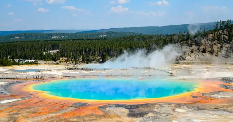
Park rangers at Yellowstone field a question that catches first-time visitors off guard: where is the volcano? People arrive expecting a cone on the horizon, a single peak with a crater at the top. Instead they are already standing on it. The volcano is the ground under their feet, and it is far too large to take in from any one vantage point.
The most violent event in its recent geological history did not build a mountain. It made a hole, one big enough that you can drive across it without realising you have crossed anything at all.
The eruption that remade the landscape
The event that shaped the modern park is called the Lava Creek eruption. It happened about 640,000 years ago. It was the third of three enormous explosive eruptions driven by the Yellowstone hotspot over the past 2.1 million years.
The numbers are what make it hard to picture. The eruption ejected more than 1,000 cubic kilometres of material, laid down as a deposit known as the Lava Creek Tuff. The 1980 eruption of Mount St. Helens, a major event by any ordinary measure, produced a tiny fraction of that — Yellowstone’s Lava Creek eruption was roughly 2,500 times larger.
How a caldera forms
Despite the name, a caldera is not a crater blasted open by an explosion — it is what’s left when the ground above a drained magma chamber collapses inward. When a large eruption empties a magma reservoir faster than it can refill, the rock above the now-empty space loses its support and drops. The general process geologists describe is straightforward in outline: the eruption “evacuates a significant amount of magma from the chamber, causing the overlying crustal block to subside into the resulting void space.”
At Yellowstone the ground sank by hundreds of metres as the chamber roof gave way, leaving a steep caldera wall. The depression that resulted covered an area larger than the state of Rhode Island.
How the collapse actually unfolded is being reexamined. A recent USGS Yellowstone Volcano Observatory report concluded that the caldera’s formation was more complex than previously understood, suggesting it may have formed through a series of eruptions rather than one clean event. The team behind the fieldwork has been careful to note they do not yet have the data to settle every question.
What visitors are actually standing on
The standard figures give the caldera as 45 by 85 km. Its real edge is messier than that tidy rectangle implies. As Yellowstone geologist Morgan Nasholds put it, “The actual outline of Yellowstone caldera is immense—it is an irregular oval shape covering approximately 67 x 42 kilometers (42 x 26 miles).”
This is why the volcano hides in plain sight. There is no single mountain to point at because the volcano is not a mountain. As Nasholds describes it, “The entire caldera is considered ‘the volcano,’ and instead of having a single edifice or centralized series of vents, it includes multiple, complex vent structures spread throughout its area.” Geologists worked out its boundary by mapping rock on the ground starting in the 1950s, not by spotting it from above.
The scale runs against ordinary intuition about volcanoes. A feature you can hold in a single view feels like a volcano. A feature so wide it carries lakes, forests, and roads inside it does not register as one, even when millions of people a year walk across it.
What the system is doing now
The caldera is far from inert. The same heat that fuelled the Lava Creek eruption now drives the park’s surface plumbing. Yellowstone holds thousands of hydrothermal features and about half of the world’s geysers, the visible exhaust of a hot system below.
The magma itself is not a churning lake of liquid rock. The reservoir beneath the caldera is understood to be a mostly solid mass of crystals with melt distributed through it, sitting several kilometres down. Since the last caldera-forming event the system has produced approximately 80 mostly nonexplosive eruptions. The most recent lava flow inside the caldera was the Pitchstone Plateau rhyolite, roughly 70,000 years ago, though USGS researchers have since dated a basalt flow west of the park to around 35,000 years ago, now considered the youngest known Yellowstone eruption.
The observatory tracks the ground rising and falling in cycles measured in centimetres, along with steady earthquake activity. As of 2026 the USGS lists the Yellowstone alert level as NORMAL with a green aviation code, the routine background state for the system.
The ground reads as scenery, a wide valley ringed by hills, the kind of view that asks nothing of the visitor. The map underneath tells a different story: a collapsed floor over an emptied chamber, a hole so large the eye cannot hold its edges.
The post Around 640,000 years ago, the ground beneath Yellowstone blasted out more than 1,000 cubic kilometers of rock, then collapsed in on itself — carving the 45-by-85-km caldera that visitors still walk across today appeared first on Space Daily.